Copy link URL:
Health Zones
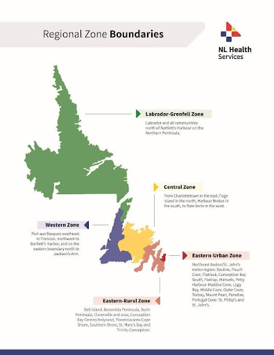
Health Zones
To ensure regional representation, NL Health Services is comprised of the following five health zones:
Central
Communities extending from Charlottetown in the east, Fogo Island in the north, Harbour Breton in the south, to Baie Verte in the west.
Eastern-Rural
Communities including Bell Island, Bonavista Peninsula, Burin Peninsula, Clarenville and area, Conception Bay Centre/Holyrood, Placentia area-Cape Shore, Mobile, Southern Shore, St. Mary’s Bay and Trinity-Conception.
Eastern-Urban
Northeast Avalon/St. John’s metro region: Bauline, Pouch Cove, Flatrock, Conception Bay South, Foxtrap, Manuels, Petty Harbour-Maddox Cove, Logy Bay, Middle cove, Outer Cove, Torbay, Mount Pearl, Paradise, Witless Bay, Bay Bulls, Portugal Cove-St. Philip’s and St. John’s.
Labrador-Grenfell
Labrador and all communities north of Bartlett’s Harbour on the Northern Peninsula.
Western
Communities from Port aux Basques southeast to Francois, northwest to Bartlett’s Harbour, and on the eastern boundary north to Jackson’s Arm.